This story was made in collaboration with Safe Software partner Avineon Tensing.
![]()
Preventative crowd management for SAIL Amsterdam 2025
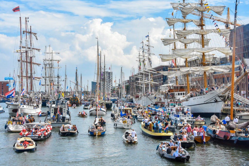
Held every 5 years, SAIL Amsterdam celebrates the Netherlands’ maritime heritage, drawing ships, sailing crews, and millions of visitors to Amsterdam’s IJ River. Set to draw massive crowds and water traffic, attendee safety was top of mind for the Amsterdam Amstelland Security Region (VRAA), a collaborative partner of the City of Amsterdam. To proactively manage crowd and event safety, the VRAA worked with Safe Software partner Avineon Tensing and other supporting parties, known as the Information-Driven Safety Fieldlab*.
Their shared goal was to create a Common Operational Picture for SAIL 2025—a real-time, interactive view that all emergency and safety partners could rely on and base actions upon. To achieve this, Avineon Tensing used FME to help build a digital twin of the SAIL area, integrating event and safety organization data to provide a shared understanding of conditions across land, water, and air.
Solving complex data integration challenges with FME
As the VRAA’s integration partner for SAIL 2025, Avineon Tensing used FME to help solve complex data integration challenges and ensure real-time data was provided to key stakeholders. Geospatial data came in many formats and coordinate systems, and different services were used for data visualization. With FME, Avineon Tensing standardized these inputs to create a reliable data foundation.
To reflect the fast-changing conditions of SAIL, data needed to be processed and updated in real time. FME’s CPU-Usage Engines were used for real-time streams, enabling faster insights and more informed decision-making.
Initially, several Kafka streams were processed through a single workspace using standard engines. With only a handful of engines available, the team developed a workaround to distribute data across multiple WebSocket streams, which added processing overhead and increased CPU usage. By transitioning to CPU-based engines and dedicating 1 engine per Kafka stream, performance improved significantly. This change reduced latency and lag, and increased throughput. During the 5-day event, 16 real-time data streams ran efficiently using just 20-40 CPU hours, compared to 6 standard engines that would have been bottlenecked over the same period.
To enable seamless real-time data exchange, FME connected to KPN’s Data Services Hub (DSH), a real-time data platform built on Apache Kafka. The DSH uses a hub and spoke model to share information between data producers and consumers. Within this system, FME acted as both, sending sensor data from providers into the DSH and retrieving live data and intelligence to feed the digital twin visualization. This two-way connection supported data flow between systems, keeping the Common Operational Picture current and aligned with real-world conditions.
For emergency services to be able to act on information-driven insights, the data had to be easy to access and interpret. Using FME, Avineon Tensing converted real-time data to WebSocket, a format supported by Map Gallery. This helped provide a clear, visual display for emergency services to see the IJ River and surrounding event area during SAIL 2025.
Guiding emergency services with a real-time digital twin
The digital twin served as the backbone of the Common Operational Picture, integrating each event and safety organization’s data into one map to act on multiple data sources and predict outcomes across organizations. Built on a detailed basemap and 3D mesh of the SAIL area, it integrated both static and live data to deliver a complete, real-time representation of the event. Static information was read directly into the visualization platform, and numerous real-time data sources passed through FME, including:
- Vessel positions (AIS and radar), with designations for SAIL’s tall ships
- Crowd monitoring sensors from cameras and mobile devices
- Road traffic intensity, based on vehicle speeds
- Environmental inputs, such as heat sensors and drone detection sensors
- Safety data, including emergency vehicle locations, active incidents, and additional safety measures drawn geospatially
This interactive display gave emergency services a shared operational view that supported quick, coordinated decisions. Having a live picture of activity across land, water, and air made it possible to proactively manage risks like heat stress, overcrowding, accessibility, and public safety.
Source: IGV Fieldlab
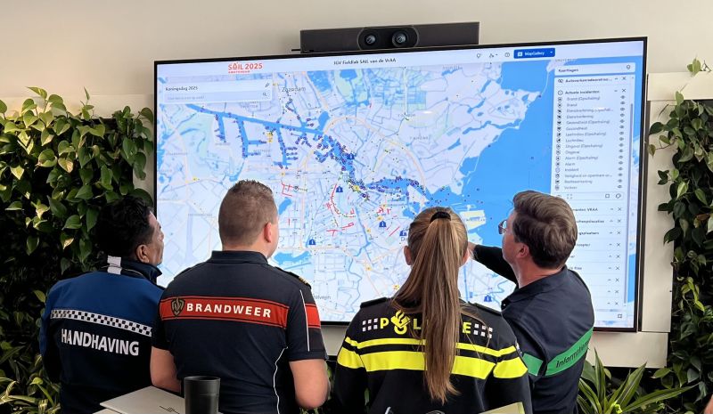
At a King’s Day trial event, key emergency and safety organizations, including Handhaving (the Municipal Enforcement of Amsterdam), Brandweer (The Amsterdam Fire Department), Politie (Amsterdam Police), and the Safety Coordinator of the Amsterdam-Amstelland Safety Region, review the Common Operational Picture.
Traditionally, each organization monitored their own systems and shared updates independently when relevant. The Common Operational Picture offered a novel solution by providing a unified view that combined information from different data sources. Every department could now operate from the same shared perspective, providing an output that was greater than siloed views.
A common operational picture to predict and prevent incidents
During the event, Avineon Tensing worked from a central boiler room alongside IGV Fieldlab members and emergency teams. Using the Common Operational Picture, they delivered ad hoc reports, monitored live conditions, and made real-time, data-driven decisions. For cross-team visibility, the digital twin was also shown on each supporting person’s screen within the crowd and safety management centres (Operational Mobility Centre) across multiple locations. This collaborative approach helped the team predict and prevent emergency incidents from occurring.
Source: IGV Fieldlab
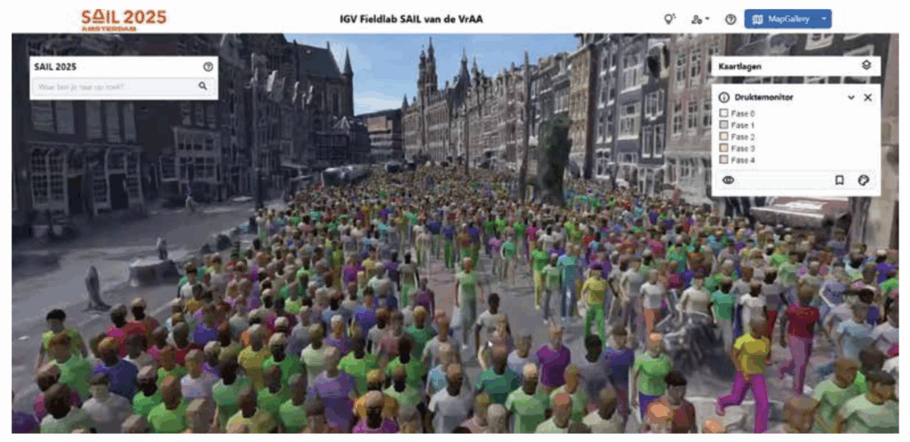
UCrowds’ solution, SimCrowd, simulates crowd movement, attributing unique personalities to each person and forecasting pedestrian flows. Simulations are linked to real-time operational platforms to support shared operational awareness. Throughout SAIL 2025, real-time simulations based on sensor data were experimented to predict events.
Operating from a unified view, emergency services could answer critical questions, such as:
- Which streets or squares are becoming overcrowded?
- Where are traffic jams forming on access routes?
- How far is the nearest emergency service from an incident?
- How crowded are the designated sailing routes?
- Are there any incidents, and if so, where?
Looking ahead, there are plans to expand the project beyond SAIL for application to large power outages and urban resilience. The digital twin will also be used during other major Dutch events like King’s Day, Pride, and memorial services. With FME, Avineon Tensing helped regulate crowd flows, maintain accessible walking routes, and ultimately support a safe and enjoyable SAIL event for 2.5 million visitors.
*The Information-Driven Safety (IGV) Fieldlab is a collaborative initiative realized by the VRAA and partners like Avineon Tensing to enhance safety during large-scale events. Data integration specialists at Avineon Tensing play a key role in achieving this mission through innovation and technology.