Planning, managing, and delivering modern transportation services starts with a good data integration plan. For example, by leveraging real-time data and automation, organizations can improve the safety, reliability, and efficiency of their transportation networks. And by connecting data across departments, valuable insights can be delivered to the right people, both across teams and to the public.
FME, Safe Software’s all-data enterprise integration platform, enables organizations to streamline processes and integrate applications. From automating complex planning frameworks to creating public-facing interactive maps, FME empowers transportation agencies to make data-driven decisions that optimize operations and enhance safety.
- Automating real-time data integration workflows can help improve transportation projects from railway management to infrastructure development. Learn more about FME for Transportation
Here are 8 case studies showing how FME helps transportation professionals save time, reduce costs, and improve the accuracy and accessibility of data.
1. Automate and simplify urban & transport planning
Auckland Transport, facing increased demand on its transportation network, sped up its planning process by creating the Roads and Streets Framework (RASF). RASF uses FME to assess and visualize complex data, combining Place and Movement values to score and categorize roads based on their community importance and transport role. This automation reduces planning timelines from years to months, enabling real-time assessments that guide decisions on public transport, safety, and freight priorities. This helps Auckland Transport meet the city’s growing needs, ensuring a sustainable and efficient transportation network for the future.
Learn more about Auckland Transport’s customer story

2. Process survey data in real-time to increase operational efficiency
NZ Transport Agency Waka Kotahi (NZTA) transformed its data management workflow by automating updates for the Intelligent Transport System Network (ITSN). Updating network device records from ITSN equipment surveys previously took nearly a full day and required manual handling of submissions and photo attachments. Now, data from ArcGIS Survey123 submissions are processed in real-time, allowing records to be updated in just five minutes. This solution streamlines photo submission, maintains data integrity, and ensures rapid data access for analysts and stakeholders. The automation has not only increased operational efficiency but also built stronger stakeholder confidence, enabling NZTA’s Geospatial team to focus on more critical tasks.
Learn more about NZTA’s customer story
3. Create an interactive map to centralize data and promote community engagement

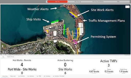
Napier Port implemented an interactive Port Activity Map for the construction of its new Te Whiti Wharf, integrating data to provide real-time visibility into site work, daily operations, and environmental factors. The map centralizes data on shipping, safety hazards, and environmental sensors, enabling faster response times and better planning. Their solution also helped with conservation efforts, helping to establish a sanctuary for little blue penguins, track their movements, and share data with the public.
Learn more about Napier Port’s customer story
4. Integrate applications across teams to create a unified, scalable data model
Strukton Rail transformed railway infrastructure management for Sweden’s rail network by implementing a scalable, automated data model. They used FME to integrate applications like Cityworks, ArcGIS, ERP, and Payroll to streamline work orders, data sharing, and invoicing, while providing real-time data access across teams. This automation supports Strukton’s commitment to maintaining safe, reliable rail systems, ensuring data is always accessible to decision-makers through Power BI analytics. This modernization has standardized workflows and simplified data sharing with clients, positioning Strukton Rail to continue enhancing automation and operational efficiency.
Learn more about Strukton Rail’s customer story
5. Modernize systems to improve efficiency and accuracy
The Utah Department of Transportation (UDOT) implemented a statewide e-ticketing system, leveraging FME, ArcGIS Online, and Survey123 to streamline materials data processing, enhance safety, and improve project administration. This system enables real-time ticketing, where materials suppliers send e-tickets that inspectors can access and update on mobile devices, with FME automatically integrating ticket data into UDOT’s geodatabase. The switch to digital workflows reduced processing time by 80%, improving efficiency and accuracy while eliminating paper tickets. With significant cost savings and positive stakeholder feedback, UDOT plans to expand e-ticketing to cover additional materials and assets statewide.
Learn more about UDOT’s customer story
6. Provide live data to the public to improve safety and traffic flow

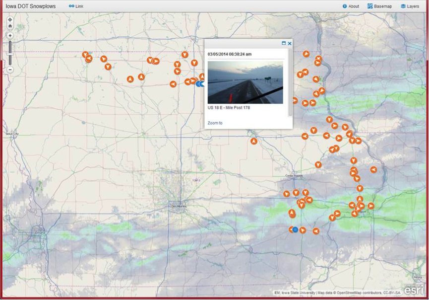
The Iowa Department of Transportation (DOT) improved public safety by providing real-time road conditions and snowplow data to the public through user-friendly maps and APIs. Facing the challenge of dispersed data from snowplows, cameras, and other traffic operations, Iowa DOT used FME to integrate data from multiple sources, creating real-time workflows to provide traffic updates in formats accessible to the public. The system enables drivers to make informed travel decisions, especially during winter conditions, and includes a live-update map used by local media. This initiative supports safer roads and bridges across Iowa.
Learn more about Iowa DOT’s customer story
7. Automate data processing to improve response times and enhance decision-making
Transport for London (TfL) implemented a robust flood risk management system for the London Underground, transforming how they assess and mitigate flooding. By integrating 5,000 datasets, including terrain and water main data, FME allowed TfL to automate data processing, reducing processing time by 13 weeks annually and saving £15,000 in survey costs. This centralized, up-to-date system enables GIS users to conduct their own analyses and provides real-time flood risk updates, improving operational response. TfL further developed predictive flood models and automated Ordnance Survey data transformations, allowing the GIS team to prioritize high-risk assets, streamline workflows, and enhance decision-making across departments.
Learn more about TfL’s customer story
8. Improve accuracy and data quality during transport construction
Arup, a global engineering firm, streamlined 3D clash detection for the Sydney Light Rail System expansion by automating data integration. Traditionally a manual process, clash detection identifies interferences in building components, such as plumbing and ductwork, to prevent costly construction errors. Arup’s FME workflow integrated data from GIS and CAD sources and transformed it into 3D models and a web interface, significantly reducing time and manual effort for engineers. This automation enhanced data accuracy and enabled utility asset owners to adopt the enhanced data for their own systems.
Learn more about Arup’s customer story for the Sydney Light Rail System expansion
Data integration workflows are an essential component of handling modern transportation data. Whether an organization is planning new infrastructure, providing real-time insights to the public, or any number of other scenarios, FME can help improve the project’s efficiency, safety, and sustainability.


