
This work was done in collaboration with Safe Software partner IMGS.
![]()
This work was done in collaboration with Safe Software partner IMGS.
![]()
Waterford City and County Council is responsible for local government in the City and County of Waterford, Ireland, serving 127,000 citizens in the region. The authority is responsible for the delivery of a range of services, including housing, transportation, planning and more, with a focus on making the land they oversee an attractive place to live, work and invest. The county is using spatial data to help deliver these services in a more timely, focused, and efficient manner.
Faced with the challenge of addressing a range of active customer care cases—primarily environmental maintenance reports throughout the county—they aimed to create mapping applications and dashboards that would become as standard at their organization as everyday tools like Outlook and Excel for carrying out tasks. The traditional list views in their CRM system lacked the dynamism needed for effective and efficient service delivery. They also faced the added challenge of ensuring staff and senior management would embrace the new spatial element of their work.
 The traditional list view
Enter FME, the game-changing solution that provided the tools necessary for Waterford to leverage a range of data in their backend application—including their CRM, financial management system, and address data systems. The county utilized FME for data integration, cross-referencing, spatial analysis, auditing, validation, and nightly data synchronization. Any anomalies detected are reported to relevant staff, ensuring accurate and up-to-date information.
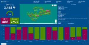 The new and improved spatial view
The data is then delivered to their centralized ArcGIS Enterprise platform and made available in ArcGIS Online so staff can access data in the field using mobile apps, and the public can access relevant data via mobile responsive maps and dashboards, enhancing field accessibility and public engagement. Using automated reports and map-based, filterable dashboards also reveals deep insights into case and records management.
The adoption of visual dashboards has fundamentally changed how Waterford addresses its residents’ needs. New insights assist with timely responses to daily requests and aid in planning and prevention efforts. Cases are now more efficiently allocated to the right team, and data is easily accessible in a centralized location. Before the FME solution, 5490 cases were closed in a year. Once the visual dashboard was introduced, 6834 cases were closed in the following year, translating to an increase of almost 25% in cases closed. The cultural impact has also been profound: both staff and senior management not only embraced the new tools but also began using them daily, marking a complete cultural shift within the organization.