This work was done in collaboration with Safe Software partner Consortech.
![]()
This work was done in collaboration with Safe Software partner Consortech.
![]()
The City of Greater Sudbury is geographically the largest municipality in Ontario and the second largest in Canada. Among other values, the City encourages innovation, continuous improvement and creativity. To support this, the Data and Geospatial Services Department was recently created to provide focus and enable the City to take advantage of geomatics and business intelligence (BI).
The City’s auditor recommended monitoring and recording road patrol activities on network maintenance so that the administration could respond more efficiently to resident claims. While exploring possible new specialized software, they concluded that acquisition, indirect integration, and maintenance costs would outweigh the benefits.
The Data and Geospatial Services Department proposed a less expensive solution that could maximize the investment they had already made in FME while keeping change management concerns in mind.
The project was divided into five phases so users and managers could gradually digest and adopt the changes.
In the first phase, ArcGIS QuickCapture was deployed to help users collect data on deficiencies from a moving vehicle. The second phase involved facilitating information access through FME by compiling those deficiencies daily and emailing a report. This step was crucial for considering change management and made information more easily accessible, as forepersons now had the option to view the Excel file they received daily rather than log into a GIS app.
The third phase involved the creation of a dashboard to provide managers with a quick overview of roads that met or didn’t meet the Minimum Maintenance Standards. Data from quick capture patrols was fed automatically through an FME workspace to ArcGIS Dashboards. Managers embraced the new dashboard as a powerful decision-support tool.
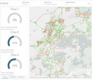
Screenshot of dashboard including a global note and a visual of deficient segments
In phase four, an ArcGIS Survey123 form was developed to obtain accurate information for litigation cases and claims. When a form is submitted, a webhook triggers an FME Flow automation, which retrieves and delivers the requested data in Excel format. Finally, in phase five, creating work orders in Cityworks was automated using FME. When a field team reports a deficiency, ArcGIS QuickCapture triggers an FME Flow webhook, launching a workspace that gathers necessary information and sends a request to create the work order. The improved process allows Public Works managers to associate each deficiency with a repair intervention more easily.
With the project’s success, Sudbury is pushing to automate all associated activities completely. Using FME, the Public Works team can now access real-time accurate information for optimized decision-making and has digitized 6000 documents while saving 980 hours of work each year. The City’s risk department handles claims faster, enhancing resident service, and the IT department minimized costs by eliminating the need to purchase and maintain an additional application. Thanks to ArcGIS and FME, mobile devices are expected to bring further improvements in the near future.
Dive deeper into Sudbury and Consortech’s success story.