Hurunui District Council transforms community engagement with FME-powered interactive map
The Hurunui District Council leveraged FME to bring its vision of an interactive map to life, ensuring the community stays informed about project scopes, progress, and budget allocations.

Redefining engagement with FME and ArcGIS Online
The Hurunui District Council is a local government authority in New Zealand with a resident base of less than 13,000 people. Tasked with providing governance and essential services to the residents and businesses within the district, the council is responsible for implementing policies that promote the well-being and sustainable development of the community.
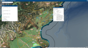
The Hurunui District Council set out to create an interactive map for their Long Term Plan projects, aiming for a transparent, user-friendly design. The map not only engages the public but also provides visibility into project scope, progress, and budget details as it relates to property, public services, roads, water supply and more. In building the map, the goal was to ensure a positive customer experience for the community and a simple and sustainable solution for monthly updates by project staff, recognizing the challenges of being a small organization.
Mapping success: FME elevates Hurunui’s data management
The partnership between FME and ArcGIS Online has resulted in a comprehensive interactive map solution with various components. This includes a hosted feature layer on the ArcGIS Online platform, which serves as a central repository for all projects. Through a smart editor, the project team can create and edit project geometries and identifiers that are ready to receive monthly data updates. Additionally, information accessibility has been improved by filtering projects based on their status, leading to two public views: current projects and completed projects. FME ensures streamlined and accurate monthly updates of project information, maintaining data quality and consistency. The introduction of an intuitive gallery app and an optional backup restore feature delivers easy self-service data updates while preserving data integrity. FME supports the effortless and efficient management and updating of project information on a regular basis.
The interactive map is a valuable resource for the Hurunui District community, fostering transparency and engagement. It allows the largely rural community to stay informed about ongoing and completed projects as they relate to Council assets, infrastructure and services. Eliciting positive feedback and hundreds of views since being launched in April 2023, the map has quickly established itself as a reliable resource for real-time information. The project is considered hugely successful with a proportionally high amount of map views for the small population. With FME, the council not only enhanced public engagement but also simplified the data management process, demonstrating a commitment to open communication and digital innovation in local governance.


Real change is just a platform away.
FME is ready to put your data to work and transform your business today. Are you?