
Integrating FME and ArcGIS opens new doors to operational efficiency and smarter decision-making. At the Peak of Data and AI 2025, we saw two innovative case studies: one that automates real-time environmental monitoring for construction permitting, and another that streamlines bulk editing of massive geospatial datasets.
Watch the recordings of both sessions for details and technical tips: Real-Time Insights & Scalable Editing with ArcGIS.
Enhancing environmental monitoring with real-time data integration
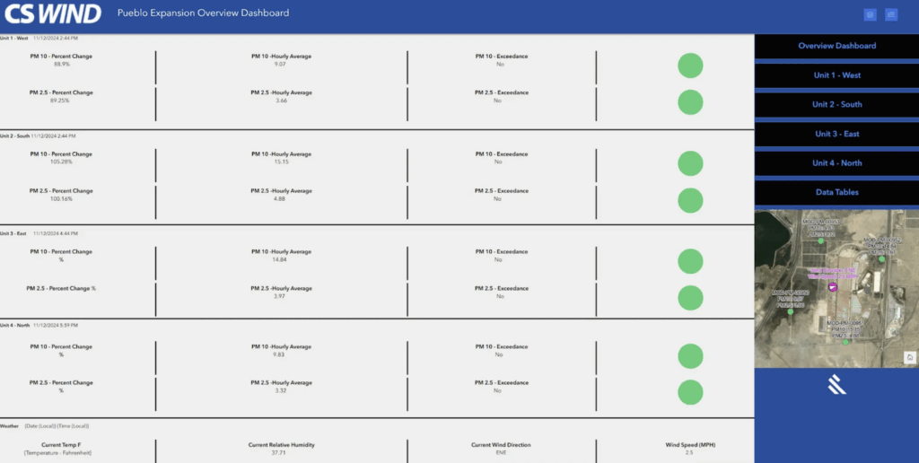
A $300 million manufacturing expansion project stalled due to challenges in acquiring an ambient air monitoring permit. Regulators required proof of compliance with air quality standards related to particulate matter. The original compliance strategy demanded labor-intensive, manual logging and calculations by construction staff every 15 minutes, which was an impractical expectation for a busy site.
To address this, 1898 & Co. developed an automated real-time environmental monitoring system that seamlessly integrated:
- QuantAQ PM Sensors: Solar-powered, cellular-connected monitors installed at four cardinal points around the construction site, plus a weather station to track wind and humidity.
- FME: Every 15 minutes, a scheduled FME Flow job pulled sensor data via an API, computed rolling hourly averages and percentage changes, and determined if thresholds were exceeded.
- ArcGIS Online: Monitoring data, actions taken, and compliance records were logged into AGOL feature tables and displayed in dynamic dashboards.
- Survey123: When thresholds were exceeded, an email alert prompted construction crews to complete a brief survey about on-site conditions and mitigation steps taken.
This project was a success, enabling smart alerts and action tracking. FME detected sensor anomalies and exceeded thresholds, triggering targeted emails and guiding users through responsive actions. By embedding wind direction logic into the workflow, the solution could differentiate between onsite and offsite particulate matter sources, helping attribute causes accurately. Plus, by using ArcGIS for real-time and historical data visualization, they simplified regulatory compliance and made it easy to export data for audits.
The permitting agency approved the project based on the automated monitoring solution, without the need to hire a dedicated compliance monitor. The system was praised by both the state and the EPA as a model for future environmental oversight.
Scalable data editing with ArcGIS REST API and FME
TRC Companies faced a post-migration task with the largest natural gas distribution company in the United States: updating and inserting hundreds of thousands of features in a newly deployed ArcGIS Utility Network.
Using FME’s flexibility and REST API support, the team developed a robust and reusable workflow. FME generated JSON arrays grouped by edit type (add, update, delete), including both geometry and attributes. Edits were chunked into batches and submitted in parallel using the HTTPCaller transformer, dramatically reducing processing time. For secure token handling, portal credentials and service tokens were dynamically generated and managed with FME User Parameters. They incorporated error handling by filtering failed batches for diagnostics, with manual or automated retries possible.
TRC successfully executed complex bulk edits with speed and precision, saving significant time and operational costs. Processing that would’ve taken hours or days was completed in minutes—even for datasets with over 100 attributes. Plus, their FME workspaces were highly configurable, enabling rapid deployment across different projects. This solution paves the way for similar edits in future projects, particularly in large-scale migration or data maintenance scenarios.
Learn More
These case studies highlight the versatility of combining FME with ArcGIS. To learn more, visit the following resources:
Tutorial: FME and Esri ArcGIS Online and Portal