ArcGIS Data Interoperability: 6 ways to use this Esri extension


There’s a reason Esri has the dominant share of the GIS industry. ArcGIS is to geo geeks what Photoshop is to a hipster with a Nikon. But here’s the thing: hundreds—thousands—of data formats exist, each tailored to represent data in a specialized way, and ArcGIS natively supports only a handful.
Without a way to get non-Esri data into ArcGIS, geoinformatics projects can become frustratingly limited in scope. Imagine you and your data standing in opposite sides of a glass prison, palms pressed against it, unable to reach each other … so close, yet so far.
Enter Data Interoperability.
The ArcGIS Data Interoperability extension is the format-blending, schema-mashing, wall-melting, rocket-fueled automation machine you were longing for. This Esri extension enables you to work with over 100 data formats, both native and non-native to ArcGIS.
Based on FME technology, it adds 3 key features to ArcGIS:
➣ direct data access
➣ quick format translations
➣ powerful Spatial ETL processes
Check out the Esri Virtual Campus basic and advanced training to learn how to use each of these components, and to understand why you’d choose one over the other. (This training was authored by yours truly, which pretty much guarantees that it’s spectacular.)
The latter, the Spatial ETL tool, is a graphical environment for creating data workflows (FME Workspaces, for those of you familiar with FME). This is the component we’ll be looking at.
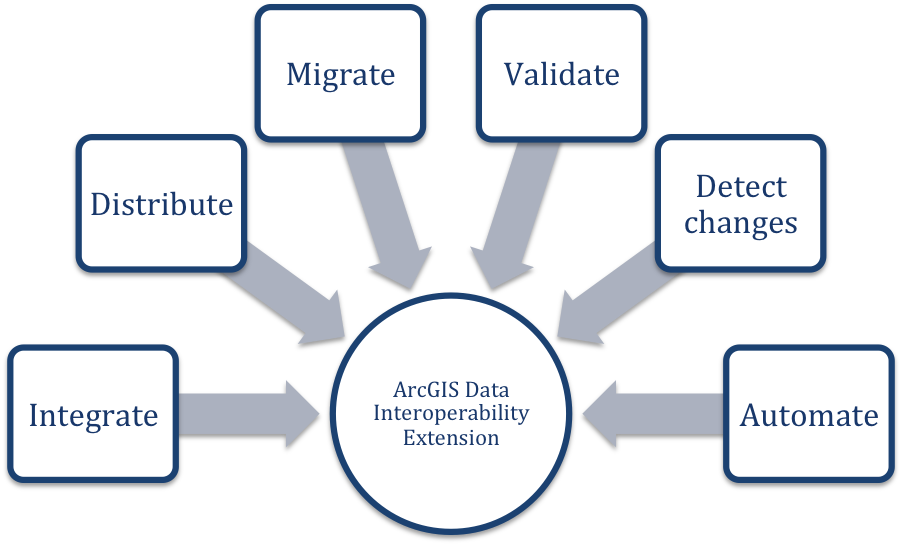
Here are the top six ways people use the ArcGIS Data Interoperability extension—hitherto called Data Interop, because that’s a mighty long name to type.

 Integrating multiple formats
For many of us, our information is stored in several disparate formats and systems. It’s a missed opportunity to work with this data independently, keeping everything separate even though it’s all very much connected. Like making strawberry-rhubarb pie but baking the filling and the crust in separate dishes. I mean, I guess that would taste fine, but it’s not the same. Also it needs ice cream.
Data Interop makes it easy to combine several datasets for easy delivery. Say you have information spread among GIS, CAD, web, and tabular sources. You can create a workflow to combine them all, taking exactly the layers (feature classes) you need and exporting one output file.
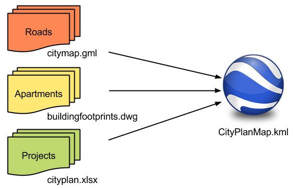
For example, you could extract all road features from a GML dataset, apartment outlines from an AutoCAD drawing, and city project information from an Excel spreadsheet, then write them all out to one KML file for easy analysis in Google Earth. (Yes, Data Interop handles all those crazy KML complexities for you.)

Data Interop supports a wide range of data types, so you can imagine the other scenarios we see—overlaying point clouds on rasters, querying databases, XML, BIM, and more.

Distributing data to different systems
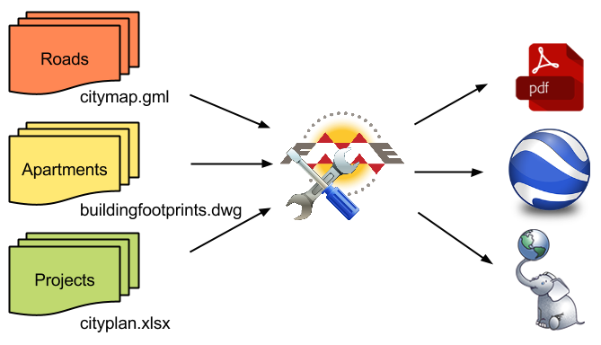
Get your data into the format that’ll make it the most useful. Do you need the straightforward familiarity of a PDF? Do you need to deliver the information to a CAD technician? Adhere to an open standard? Data Interop will help you convert to whatever destination system you need.
Building on the above example, all you’d need to do is add another destination to the workflow.


Migrating data between systems
Many geoinformatics professionals use Data Interop as a powerful migration tool. Data Interop supports several database formats, open and proprietary. The Spatial ETL workflows you design are fully customizable, letting you choose which tables, fields, and rows to move, which ones to update, and how often to perform this migration.

Data validation
We’ve seen enough data here at Safe to have developed strong feelings about data quality. (Ok, we have strong feelings about a lot of tech-related things, but data quality is a big one.) We even developed a data validation checklist to help you ensure your data is complete, correct, consistent, and compliant. The Spatial ETL tool makes it easy to check off all items in this list using a couple of transformers and the Data Inspector.

Change detection
A lot of people use Data Interop to detect changes in their datasets. This is easy to do and generally involves adding a single transformer to your Spatial ETL workflow.
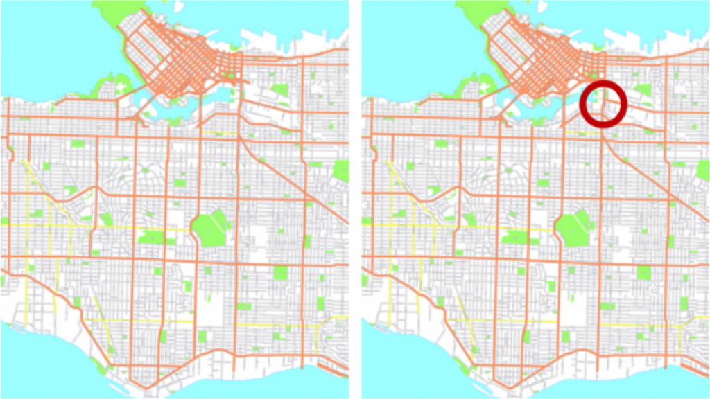
For example, say you have a “city parks” dataset from 2014 and one from 2015. Just read them both into the workflow, send them through the ChangeDetector transformer, and note the output, which will tell you what features are new, missing, or the same in the updated dataset.

Note that this method of change detection is more comprehensive than the Data Comparison toolset, which targets line geometries only.

Workflow automation
So you’ve used Data Interop to extend your format support and make some super useful workflows. Let’s look at options for automating these data conversions and transformations.
Spatial ETL tools can be integrated with other ArcGIS Geoprocessing tools in the ModelBuilder. If you’ve published a parameter (i.e. the user running the workflow can specify certain parameters, like login credentials, choosing which feature classes to read, etc.), then this is particularly helpful when the ETL tool is made a part of a bigger workflow in the ModelBuilder.
These workflows can also be published to ArcGIS Server and executed in that environment. Say you’ve created maps in ArcMap that contain spatial data non-native to ArcGIS. You can use the Data Interop extension for ArcGIS Server to publish these maps for viewing from a browser or another ArcGIS Desktop application.
Learn more and try it yourself
Download a trial of this ArcGIS extension to try out the full range of capabilities, including support for 100+ Esri and non-Esri data formats. Note that when your trial is over, even if you decide not to get a license, GML-SF and WFS support are always free.
To learn how to use the ArcGIS Data Interoperability extension, see the following courses on the Esri Virtual Campus:
- Transforming Data Using Extract, Transform, and Load Processes
- Controlling Data Translations Using Extract, Transform, and Load Processes
We also have resources for working with FME and ArcGIS Online.
Read part 2: Advanced 3D Worlds with ArcGIS Data Interoperability


 Legacy Data is traditional and values the wisdom of the past. He’s the go-to for office lore and frequently reminisces about ‘the early days’. His fax number is still operational and his office shelves are filled with paper files, plus a floppy disk or two (or twenty). Find him by the water cooler solving a Rubik’s cube or recollecting on how things used to be done. Just don’t ask him to download your pdf or move to the cloud.