“The Great BIM vs. GIS Debate” and 2.5D City Models


![]() This week’s Autodesk University was, as always, a mind stretching experience. If I had any doubt that the world my children are growing into will look little like the one I have experienced thus far, it was erased by the keynote session. The impact of those five waves of disruption (thanks Matt for summarizing) is going to make the future come quickly and radically. And in some ways, as has been expressed at Autodesk University in the past, we are already living in the future.
This week’s Autodesk University was, as always, a mind stretching experience. If I had any doubt that the world my children are growing into will look little like the one I have experienced thus far, it was erased by the keynote session. The impact of those five waves of disruption (thanks Matt for summarizing) is going to make the future come quickly and radically. And in some ways, as has been expressed at Autodesk University in the past, we are already living in the future.
For those of us geospatial folks in attendance, the highlight of this year’s show was “The Great BIM vs GIS Debate”. It really highlighted that convergence between these two fields – while underway – still has a ways to go. As well, Dan Campbell’s talk on city models once again reminded me of the important, practical role that 2.5D can play with city models.
The Role of 2.5D in 3D City Models
While one friend characterized my talk on the Free FME FDO Provider for Map3D as “GML direct read in AutoCAD Map 3D – dead sexy” (you can view a recording here – free signup required though), Dan Campbell’s talk on the ongoing evolution of the tools needed to have a truly work with a city-wide 3D Model certainly featured a lot more eye candy.
Dan made a couple of very important points – one was that to effectively use a 3D city model you need the context of the city in your model. In Vancouver’s case, this means the mountain ranges around the city need to be considered and part of any visualization if one is to really understand the impact of any decision.
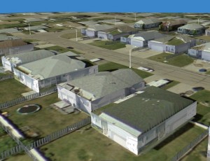
 His second key point was that it is not practical to truly get a complete 3D model of a city, where each building has been painstakingly modeled in full glory. In reality, a 2.5D model (built from extruding building footprints) supplemented with full 3D here and there is a far more realistic goal, and can be done with relatively little effort in comparison to the value it can add. We’ve used FME to apply this technique for a few customers who have been very pleased with the results. Having a citywide coverage of such buildings, together with the context of the surroundings, all integrated in the Autodesk Infrastructure Modeler has certainly brought the City of Vancouver’s city model to a new level of both realism and usefulness.
The Great BIM versus GIS Debate
But the highlight of the conference for me was “The Great BIM versus GIS Debate”. We’ve been thinking about how these two universes can co-exist for some time at Safe, and so I was very interested to see what the mix of Spatial Sustain’s Matt Ball (as moderator) and Autodesk’s dynamic duo of Michael Schlosser (BIM) and Peter Southwood (GIS) would result in.
Each side scored some strong hits while debating in front of a fully engaged, packed room, but there was no knockout punch. At various times members of the audience chimed in, and possibly landed the best zingers of the event. My highlights were:
- GIS has been around since 1854, whereas BIM has only been around, according to Wikipedia, since 1987. Consequently, GIS technology has had longer to mature and scale to larger and larger problems.
- The I (information) is the important (and common) letter in GIS and BIM. One audience member asked why we don’t speak of “WIM” –Worldwide Information Models.
- The G in GIS stands for Geographic, but one audience member thought in reality GIS systems are really Spatial Information Systems, and can equally as well be applied to data at the molecular, interplanetary, and, though James disagrees, building internals level.
- “GIS is a coat rack to hang all your information off of.”
- According to Southwood, “GIS stands for Get It Surveyed!”
- There are places in the world where there is more floorspace than there is land. The floorspace is a different kind of geography.
- Peter Southwood had the best one-liner: He credited Brien Green (@geothinkers) as stating that “BIM is the illegitimate offspring of CAD and GIS .” (However, Brien countered on Twitter that BIM is really more of a love child).
- Most profound thought of the day: architect audience member Kelly Cone’s point that BIM is foremost an Information Model about a Building, not a Building Model with Information. (Take a deep breath and read it again, and feel the truth.)
It was a wonderful session (thanks to Matt for his summary), with much lively debate, and all sides coming away with a much greater shared understanding that continued work is needed to bring the accuracy and richness of the CAD and BIM worlds into the scalable universe of GIS. I have a feeling this isn’t going to be the last session of its kind, and look forward to future sessions like this one, and to your comments on the matter.


