Data never stands still. Whether it’s an evolving customer database, a sensor feed, or new spatial data arriving daily, change is inevitable.
Many organizations still handle change tracking manually, relying on spreadsheets, custom scripts, or tedious workflows that are prone to error and hard to scale. But when systems need to stay in sync in real time, automation becomes essential.
This blog discusses how to efficiently detect, compare, and automate responses to changing data. For a deep dive and live demos, watch our webinar, Managing Changing Data with FME: Part 1 – Compare & Detect.
Types of Change Data Capture (CDC)
There are 4 common methods for CDC:
- Diff
- Modification Timestamps
- Database Triggers / Webhooks
- Log-Based Change Data Capture
This blog focuses on the first, diffing, and how to automate that using FME.
To learn about detecting changes in data models/schemas, check out our webinar on Schema Drift and our tutorial on dynamic workflows.
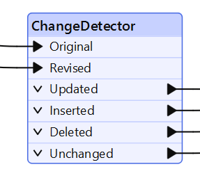
The ChangeDetector
The ChangeDetector is a powerful FME transformer that allows you to:
- Compare two datasets (old vs. new)
- Detect additions, deletions, and updates
- Output only the features that have changed
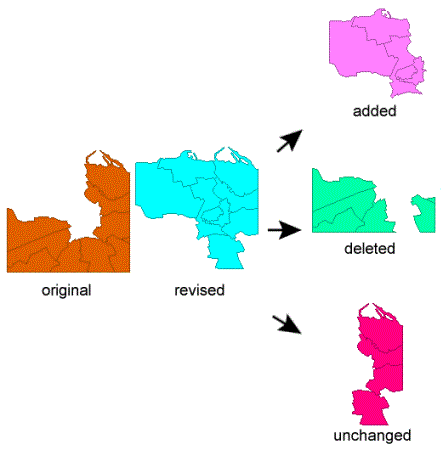
For example, if you receive a new dataset each week, you can compare it against last week’s version to isolate the differences, saving time and processing power.
Real-world examples include:
- Detecting attribute changes in tabular data (e.g. changes in property ownership records)
- Comparing geometry in spatial datasets (e.g. identifying updated building footprints)
- Performing incremental updates to a data warehouse without reprocessing the entire dataset
Automating the Workflow
FME takes change detection further by enabling full workflow automation. Once differences are detected, you can:
- Route updated features to a database or API
- Trigger alerts or notifications
- Synchronize data across systems automatically
Spatial Data Support
Many ETL tools offer some level of change tracking, but most fall short when it comes to spatial data. FME supports both geometry and attribute comparisons, so it can detect:
- Shifts in coordinates
- New or deleted features (e.g. roads, parcels)
- Geometric edits (e.g. modified building shapes)
This makes FME uniquely well-suited for GIS, land management, and utility companies where spatial change tracking is critical.
See also: Precision Tolerance in FME
Learn More
Managing changing data doesn’t have to be a manual or messy process. With FME, you can automate comparison, detect even complex spatial changes, and build workflows that keep your systems reliably in sync.
Whether you’re a GIS professional, data engineer, or business analyst, FME offers a smarter, more visual way to handle change—so you can stop worrying about what’s new and start putting your data to work.
Webinar Part 2: Managing Changing Data with FME – Flexible Approaches to Tracking Changes