What is a Coordinate? What is a Coordinate System? What are Earth Movements?
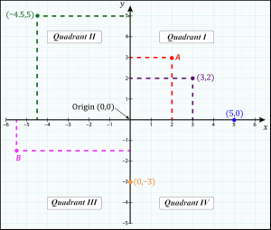
A coordinate is a set of values that show a position on earth. Coordinate systems use this information to tell us the distance between two or more points, location and direction. There are two types of coordinate systems mentioned in this blog post: geographic and projected. Both of which are horizontal coordinate systems. Most maps these days are based on these systems.
The Geographic Coordinate System combines coordinates and locations on a 3D spherical model of the earth. A datum is a factor, but not the only factor, in a geographic coordinate system. A datum represents everything you need to associate coordinates (typically lat/long/height – angular units) to a position on the Earth. For example, the datum “WGS84” means “use GPS to get a position”.
The Projected Coordinate System, on the other hand, shows how a spherical earth model is projected onto a flat map. It uses cartesian coordinates (X,Y) which are measured in a particular unit, for example meters (m), feet (ft), etc. This is produced by an algorithm, otherwise known as a Projection.

Learn more about coordinate systems
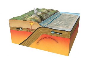
Coordinate systems can record earth movements. The earth is constantly moving and changing due to the movement of tectonic plates.
The Evolution of Coordinate Systems
As the art of spatial data has advanced, coordinate measurements don’t remain accurate because the crust of the earth is continuously shifting. There is a clear disparity in accuracy between relative and absolute positions on earth.
Remember tectonic plates? These pieces of earth are constantly in tectonic motion, causing different movements of the earth. This is especially true at plate boundaries! The industry is moving and in the near future, you could even store date and time in addition to the coordinates. This improves the accuracy of where and when tectonic plates shift. For these reasons, countries need to update their coordinate systems to ensure their data remains accurate.

Furthermore, before satellite-based mapping occurred, everyone did local surveys in their own countries. Each country modelled the shape of the Earth to the best of their knowledge according to their data. However, this was specific to just the country, not the world overall. This led to a large number of inconsistent datums, each with their own coordinate systems. This lack of global alignment of local surveys and movement of tectonic plates has pushed coordinate systems to evolve as the world becomes more aligned and aware of tectonic motions.
This is why new coordinate systems are still being created and why existing (but few) coordinate systems have incorporated a time element.
This has been done so you know not just where your data is, but when it was there too. Challenges you might face when integrating geospatial data include integrating geospatial data from different years and GIS mapping with GPS coordinates.
FME & Coordinate Systems
To convert between two different datums, there will be an equation that adjusts the point locations. Sometimes there will be a grid of adjustments instead, which is usually more accurate than the equation.
Problems arise when converting between datums on different tectonic plates, since they are moving relative to each other over time. You end up with multiple equations or grids, and need to know which one to use based on the time the data was captured to ensure results are accurate.
This didn’t used to be much of a problem, since you generally didn’t need to align data in Vancouver with data in Tokyo. However, today everybody uses GPS coordinates, and the datum for GPS coordinates is based on a consistent global view. Now, all the commonly used datums are moving compared to the GPS coordinates, as the plates move.
You can use FME to convert these datums by picking the appropriate datum shift for the data if the appropriate datum shift is defined.
Learn more about using coordinate systems within FME
Future FME updates & Coordinate systems
At Safe Software, we are constantly improving FME’s data integration functions. To transform geospatial data of the earth movements so that users can apply it to coordinate systems, we require that users provide sufficient information for FME to do the right transformation.
Some of the tectonic shift issues have been resolved by creating new datums. Examples of this include GDA94 –> GDA2020 in Australia (normal continental drift over time) and JGD2000 –> JGD2011 in Japan (earthquake). For these, you can use FME’s standard reprojection transformers today, e.g. CsmapReprojector, EsriReprojector. This will improve the accuracy of maps. We are in the process of upgrading this further so join the FME Community to learn more about these transformers and don’t be afraid to ask all your questions!


