With the increasing frequency and severity of wildfires rising in British Columbia (BC), FortisBC—BC’s largest natural gas utility and second-largest electrical utility—has expanded wildfire management into a year-round effort. To protect its customers, employees, and critical infrastructure across a geographically vast region, FortisBC needed a way to automate how it tracks and responds to evolving wildfire threats.
Expanding access to wildfire data across the organization
FortisBC’s GIS team uses FME to integrate active wildfire data from the BC Wildfire Service into their systems. Originally, this data was published to FortisBC’s GE Smallworld environment—its core GIS system—but access to Smallworld was limited to an insufficient number of users. To improve visibility across the company, the team now publishes the data to the organization’s internal Esri Portal environment. This change has allowed hundreds of users—primarily managers and field staff—to securely access internal, up-to-date wildfire data from anywhere in the province. With this data, FortisBC monitors threats to infrastructure, prioritizes response efforts, and improves operational decisions while also expanding access beyond the GIS team.
Adding satellite hotspot data for greater precision
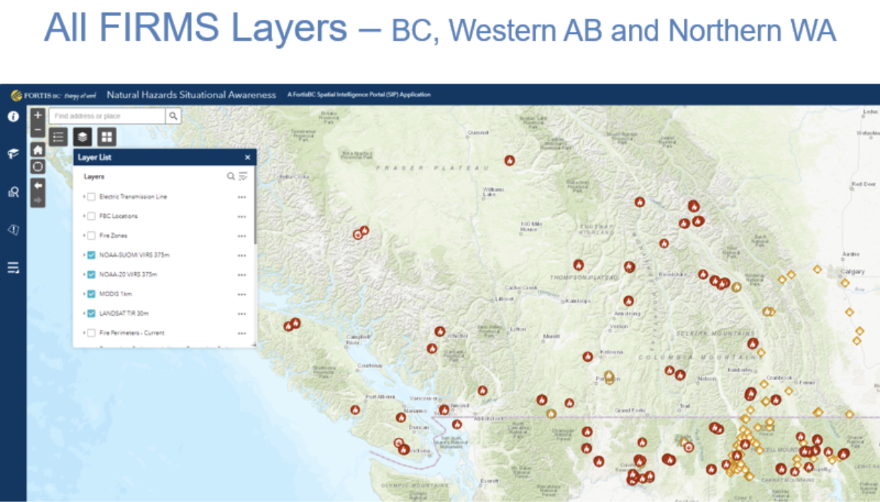
The system continues to rely on wildfire perimeter polygons provided by the BC Wildfire Service, but FortisBC has added a new level of granularity by incorporating data from NASA’s Fire Information for Resource Management System (FIRMS). FIRMS uses four satellites to detect thermal anomalies—known as hotspots—which indicate areas of active fire. Altogether, the point-based data provides far greater spatial precision, helping the team move from broad fire boundaries to a clearer view of where flames are likely burning.
FIRMS data is then downloaded every four hours and automatically processed using FME Flow, providing near real-time insight into where fire activity is most intense. The integration of FIRMS hotspot data supports FortisBC’s electric operations teams in evaluating wildfire proximity to above-ground infrastructure, such as poles and transmission lines. This capability has proven especially useful in wildfire-prone regions such as the BC interior, where FortisBC serves approximately 175,000 customers.
Automating real-time updates with FME Flow
To ensure the hotspot data remains timely and accurate, FortisBC relies on FME Flow to power a fully automated process behind the scenes. A series of nine interconnected workspaces clip relevant geographic areas (namely, British Columbia, southern Alberta, and northern Washington) and refresh the wildfire datasets regularly. These automated workflows ensure that data stays current without requiring manual intervention, allowing emergency responders and operations staff to make informed, time-sensitive decisions based on reliable information.
The integrated view of wildfire and asset data has also improved situational awareness and planning for FortisBC teams in the field. In addition to asset protection, wildfire data is used to generate evacuation zone overlays, which helps teams identify impacted customers and trigger processes such as billing suspension for evacuated households. For instance, during the 2023 Kelowna fires, the near real-time FIRMS data helped teams track fire proximity to infrastructure and plan accordingly.
Scaling FME use for long-term efficiency and impact
As wildfire response capabilities have matured, FME adoption has expanded across FortisBC. Several new users within the GIS team have begun applying FME to their own workflows, supported by internal knowledge sharing and access to training resources. While future enhancements like real-time weather data and field photo integration remain on the longer-term roadmap, FortisBC’s wildfire monitoring system has already proven invaluable and continues to evolve with the help of FME.